


GARDEN ROUTE | KAROO NEWS - In the latest weather forecast from SA Weather Service, the country is bracing for the much anticipated heavy rain and cold weather conditions.
Here is what you can expect on Thursday:
Impact-based warnings:
A. Orange Level 5 Warning: Severe thunderstorms resulting in heavy downpours leading to flooding of roads and bridges, damage to infrastructure and agricultural activities are expected over the eastern parts of Free State, extreme east of the North West, southern parts of Gauteng and extreme south-western parts of Mpumalanga.
B. Yellow Level 4 Warning: Severe thunderstorms resulting in heavy downpours leading to localized flooding of roads and bridges, large amounts of small hail and excessive lightning are expected over the extreme south-central parts of Limpopo,northern parts of Gauteng and Mpumalanga highveld as as over the northern and north-eastern parts of KwaZulu-Natal.
C. Yellow Level 2 Warning: Severe thunderstorms leading to localized damage to settlements, localized flooding of susceptible roads, low-lying areas and bridges are expected over the central part of Free State, eastern parts of North West, southern parts of Limpopo and north-eastern parts of Mpumalanga, except in the north-eastern Lowveld.
D. Yellow Level 2 Warning: Disruptive rain leading to localised flooding of settlements, roads and bridges is expected in places along the coast and adjacent interior of the eastern half of the Eastern Cape.
Advisories:
Cold and wet conditions are expected over the central and western parts of KwaZulu Natal until tomorrow 24 April, but very cold over the south-western high grounds where light snowfall is possible.
Western Cape
Morning fog in places, otherwise partly cloudy and cool. It will be warm over the western interior. The wind along the coast will be light and variable in the morning, otherwise light to moderate southerly to south-easterly but light to moderate south-westerly along the west coast in the afternoon. The expected UVB sunburn index: High
Western half of the Eastern Cape
Cloudy and cool with isolated showers and rain but scattered showers and thundershowers in the east. The wind along the coast will be moderate to fresh easterly but light westerly west of Cannon Rock in the morning.
Eastern half of the Eastern Cape
Cloudy and cool to cold with scattered showers and rain, but widespread along the coast.
The wind along the coast will be Light to moderate north-easterly but fresh in places.
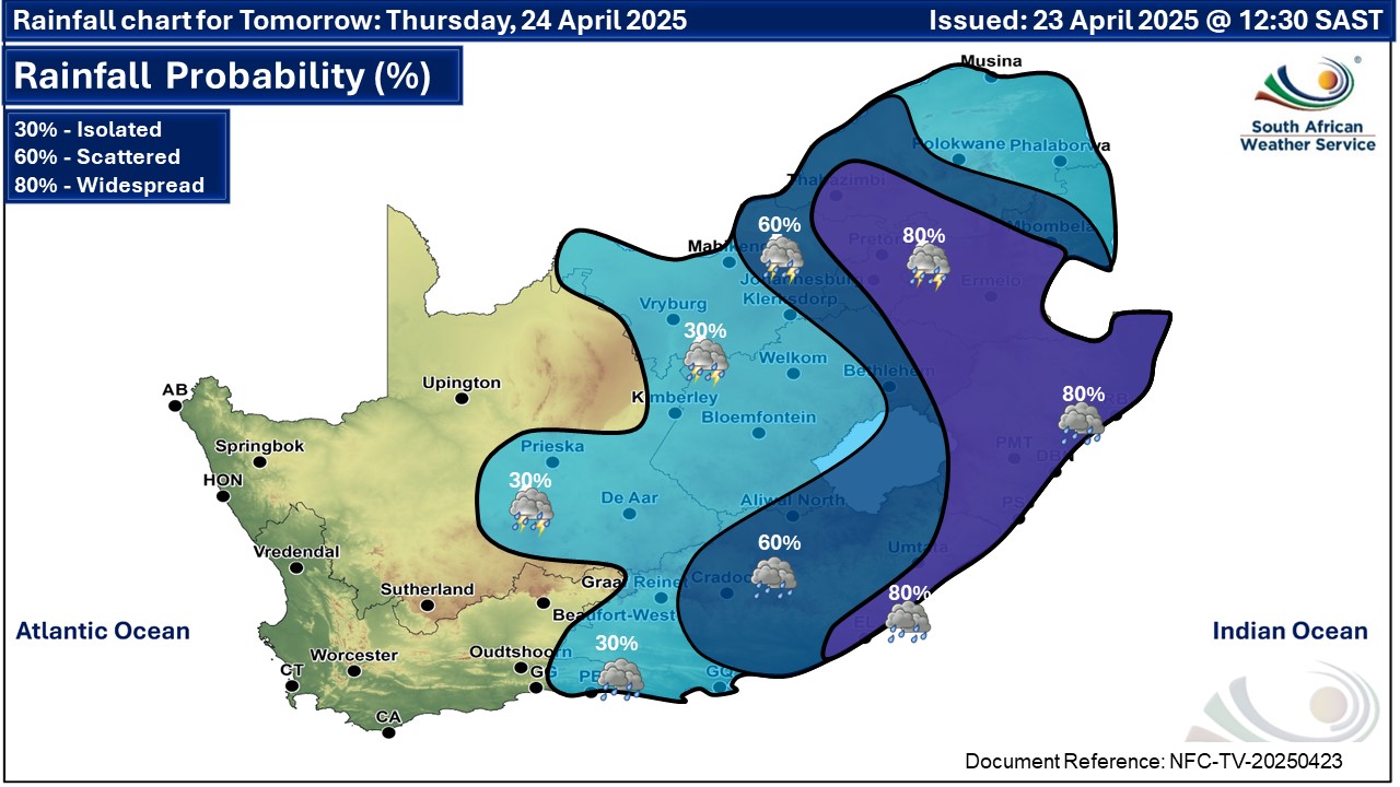
Gauteng
Cloudy and cool with widespread showers and thundershowers.
The expected UVB sunburn index: Moderate
Mpumalanga
Cloudy and cool to cold with scattered to widespread showers and thundershowers, but isolated in the Lowveld where it will be warm.
Limpopo
Cloudy and cool isolated to scattered showers and thunder-showers, but widespread in the south-west. It will be warm in the Lowveld and Limpopo Valley.
North-West Province
Cloudy and cool with isolated to scattered showers and thunder-showers but widespread over the extreme eastern parts.
Free State
Cloudy and cool with isolated to scattered showers and thunder-showers but widespread over the eastern half. It will cold along Lesotho border.
Northern Cape
Morning and evening fog in places along coast, otherwise partly cloudy and cool with isolated thundershowers over the eastern parts, but fine over the north-western parts. The wind along the coast will be light and variable, becoming moderate to fresh southerly to south-easterly from the afternoon.
Kwazulu Natal
Cloudy and cool to cold with widespread showers and thundershowers. Light snow is possible in the south-western high grounds. The wind along the coast will be light to moderate southerly to south-easterly, but light to moderate northerly to north-easterly
south of Richards Bay, reaching fresh to strong in places. The expected UVB sunburn index: Low
‘We bring you the latest Garden Route, Hessequa, Karoo news’


