


NATIONAL NEWS - Eight out of nine provinces in South Africa are expected to experience snow over the weekend and into next week.
Pretoria Rekord reports that, according to Vox Weather forecaster Michelle du Plessis, the strong cold front will arrive in the Cape early on Saturday morning, bringing heavy rain to the western parts of the Western Cape, as well as cold, wet and windy weather across much of the Cape provinces.
“This front is supported by a strong upper-air trough, helping to deepen the system.
“Then on Monday, a cut-off low-pressure system is expected to develop behind the front, with freezing levels dropping significantly across the country and snow expected to fall in eight of South Africa’s nine provinces.”
Du Plessis says the first light snow is expected late on Saturday and overnight into Sunday morning around the Cederberg mountains in the Western Cape, as well as the Nuweveld and Roggeveld mountains in the Northern Cape. Heavier snow is already likely by this stage in Lesotho.
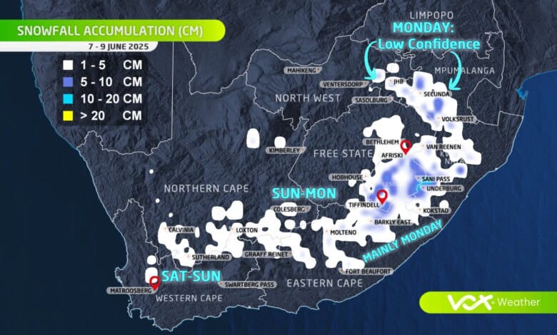
Here is what to expect on these days in terms of snowfall:
Sunday: 8 June
Light snow will spread over the high-lying regions in the Karoo — including around Loxton, Nieu-Bethesda and Noupoort.
Du Plessis adds that all models indicate the likelihood of snow over the northern highlands of the Eastern Cape, but they differ in their expected snowfall amounts.
“The GFS model suggests heavier snow, while the ECMWF shows significantly less. More snow is likely in Lesotho.”
Monday: 9 June
As the cut-off low continues to develop and freezing levels drop further, light snow remains a possibility over the southern parts of Gauteng and the southern Highveld of Mpumalanga.
However, she adds that at this stage, only the ECMWF model is showing snowfall over Gauteng and the Highveld of Mpumalanga.
“As we’ve seen many times before, cut-off lows are unpredictable, and the forecast can change quickly from day to day.
“This means snowfall over Gauteng and nearby areas is still highly uncertain, and it may disappear from the forecast entirely or shift to a chance of freezing rain instead.”
Furthermore, Du Plessis says more snow is expected in Lesotho and in regions bordering Lesotho (Free State, KZN and the Southern Drakensberg), with heavy snow likely over the mountains in the western parts of KZN.
“A very light dusting of snow is possible over the eastern regions of the Free State.”
 The strong cold front will arrive in the Cape early on Saturday morning. Photo: VoxWeather
Provinces where snow is expected or possible:
Western Cape`
- Cederberg mountains (light snow Saturday night into Sunday)
Northern Cape
- Nuweveld and Roggeveld mountains (light snow late Saturday into Sunday)
- Karoo highlands around Loxton
Eastern Cape
- Barkly East, Southern Drakensberg, Nieu-Bethesda, Noupoort (light to heavy snow likely)
Free State
- Eastern regions (very light dusting possible)
- Areas bordering Lesotho
KZN
- Underberg and western mountainous areas (heavy snow expected)
Gauteng
- Southern parts (light snow possible Monday – model-dependent and uncertain)
Mpumalanga
- Southern Highveld (light snow possible Monday – also model-dependent)
Lesotho (not in South Africa but included in the context)
- Heavy snow expected around Sani Pass and high mountains
Provinces not expected to see snow:
- Limpopo: No snow mentioned or expected in this province.
‘We bring you the latest Garden Route, Hessequa, Karoo news’


