


Update at 08:30 - Weather update: Orange level 9 warning: Disruptive rain. Affected area: Eastern Cape.
GARDEN ROUTE | KAROO NEWS - The South African Weather Service has released its latest weather forecast for Tuesday, 10 June.
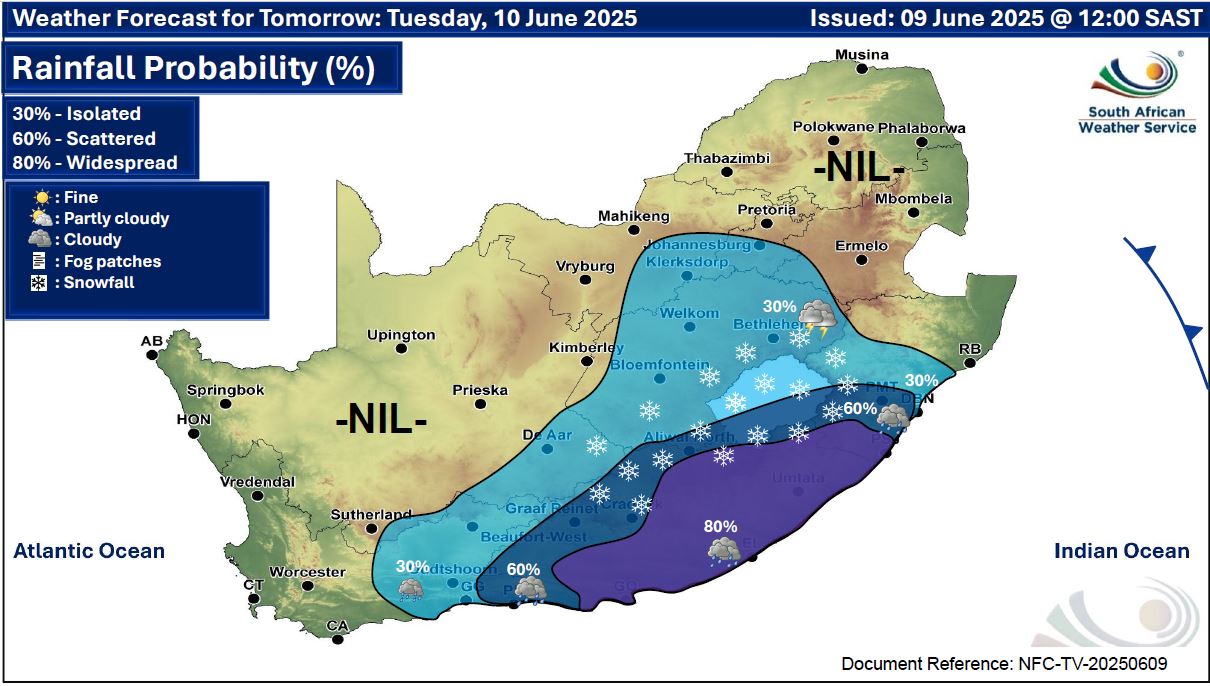
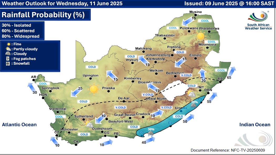
They have forecast disruptive snowfall over parts of the Free State and the Eastern Cape; as well as wet conditions over all provinces except Limpopo and the North West.
Here’s what you need to know.
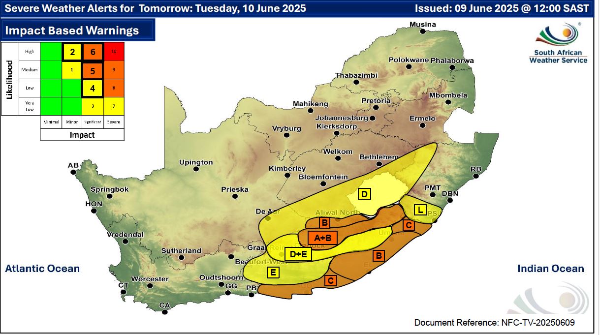
Impact-based weather warnings
A. Orange Level 6: Disruptive snow resulting in danger to life, pass closures and communities cut-off is expected over Joe Gqabi district municipality, Enoch Mgijima (Molteno) and Matatiele local municipalities of the Eastern Cape.
B. Orange level 6: Disruptive rain leading to flooding of settlements /property, roads, danger to life with some communities temporarily cut off is expected in places over Amathole, OR Tambo as well as Buffalo City district municipalities of the Eastern Cape.
This has been updated at 08:30 to a Level 9 warning as follows:
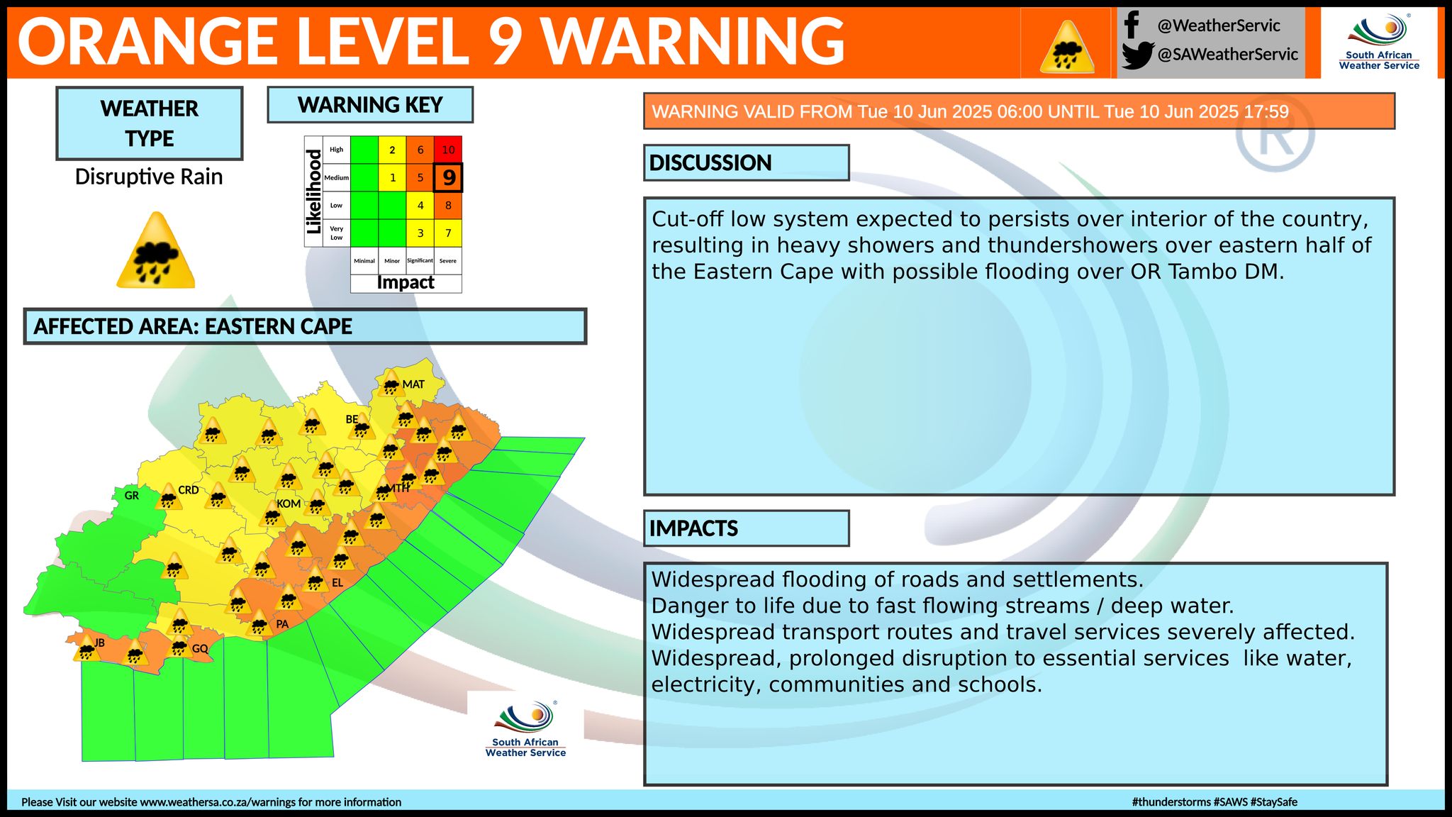
C. Orange Level 5: Disruptive rain leading to danger to life, flooding and displacements of settlements as well as mudslides is expected over Alfred Nzo, Makana, Ndlambe, Kouga, and Koukamma municipalties of the Eastern Cape.
D. Yellow Level 2: Disruptive snow leading to loss of livestock, minor passes closed and traffic disruptions due to snow and icy roads is expected over the Chris Hani district municipality, Dr Beyers Naude (Graaff Reinet), Raymond Mhlaba, Amahlathi and Umzimvubu local municipalities of the Eastern Cape.
E. Yellow Level 2: Disruptive rain leading to localised flooding of settlements, and roads is expected in places over Joe Gqabi, Chris Hani, Blue Crane Route, Dr Beyers Naude (Graaf-Reinet area), Sundays River Valley and Nelson Mandela Bay Metro municipalities of the Eastern Cape.
F. Yellow level 4 warning: Damaging winds and waves resulting in localised disruption of small harbours and/or a ports for a short period of time, small vessels at risk of taking on water and capsizing in a locality, difficulty in navigation (eg. Small vessels in short period, steep waves & hampered progress due to strong winds), and localised disruptions to beachfront activities (e.g.closure of beaches for swimming, shore/rock angling) are expected along the coast of KZN tomorrow and Wednesday.
G. Orange Level 6: Damaging winds and waves resulting in damage to settlements, some structural damage, disruption to ports/harbours and danger to vessels at sea is expected between Kei River Mouth and Port Edward.
H. Yellow Level 2: Damaging waves resulting in localised disruption to ports/ harbours, difficulty in navigation of small vessels with a risk of taking water and capsizing in a locality are expected between Port Alfred and Peddie Coast.
I. Yellow level 4 warning: Damaging interior winds resulting in localised damage to settlements (formal and informal), localised loss of agricultural production and some transport routes and travel services affected by wind or falling trees are expected in the central and northern interior of KZN.
J. Orange level 5 warning: Damaging winds resulting in injuries and danger to life from flying debris, damage to settlements (formal and informal), loss of agricultural production, some structural damage and transport routes and travel services affected by wind or falling trees are expected in the south of KZN.
K. Yellow Level 2: Damaging wind resulting in localised damage to settlements, disruption to power/communication and disruption to ports/harbours is expected in places over Buffalo City Metro, Amahlathi, Intsika Yethu, Dr AB Xuma, Elundini, Mzimbu and Matatiele local municipalities of the Eastern Cape.
L. Yellow Level 4: Disruptive rainfall resulting in localised flooding of settlements, low-lying areas, and bridges, and minor vehicle accidents due to slippery roads in the extreme south of KZN.
Advisories
Wet, windy, and very cold conditions are expected over the southern and eastern parts of the Northern Cape, the Free State and in places in the central and southern parts of North West with the passage of cut-off-low weather system, and over the Free State and the extreme south- east of Northern Cape.
Snowfalls are expected along the Lesotho border and western parts of the Free State, as well as in places in the east and south-east of the Northern Cape, and along the Lesotho border, where mountain passes are likely to be closed.
The public and small stock farmers are advised to provide proper shelter, dry bedding, and energy-rich feed to protect their animals against these conditions.
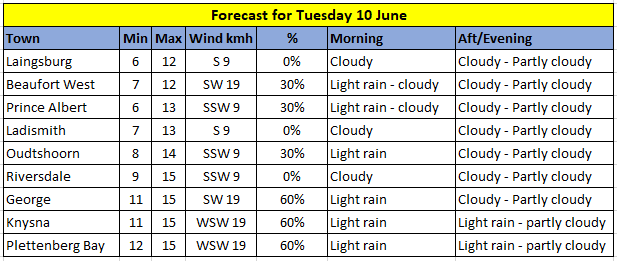
 Western Cape
Cloudy to partly cloudy and cold with isolated showers and rain in the east. It will become fine in the west from the evening.
The wind along the coast will be light to moderate south-easterly but light and variable at times along the west coast, otherwise moderate southerly to south-westerly.
The expected UVB sunburn index: Low
Western half of the Eastern Cape
Cloudy and cold to very cold with scattered showers and rain but widespread along the coast and adjacent interior.
Snowfalls are expected over the northern high-lying areas.
The wind along the coast will be moderate to fresh southerly, becoming south- westerly from midday.
Eastern half of the Eastern Cape
Cloudy, windy and cold to very cold with widespread showers and thundershowers.
Snowfalls expected over the northern high lying areas.
The wind along the coast will be strong to gale force south-westerly.

Forecast for Wednesday 11 June:
‘We bring you the latest Garden Route, Hessequa, Karoo news’


