
GARDEN ROUTE | KAROO NEWS - Very cold, wet and windy conditions are expected over the interior of the Western Cape and Namakwa district from Saturday into Monday, with possible snowfall over high-lying areas and mountain peaks leading to icy road conditions especially over the Beaufort West Municipality, according to SA Weather Service.
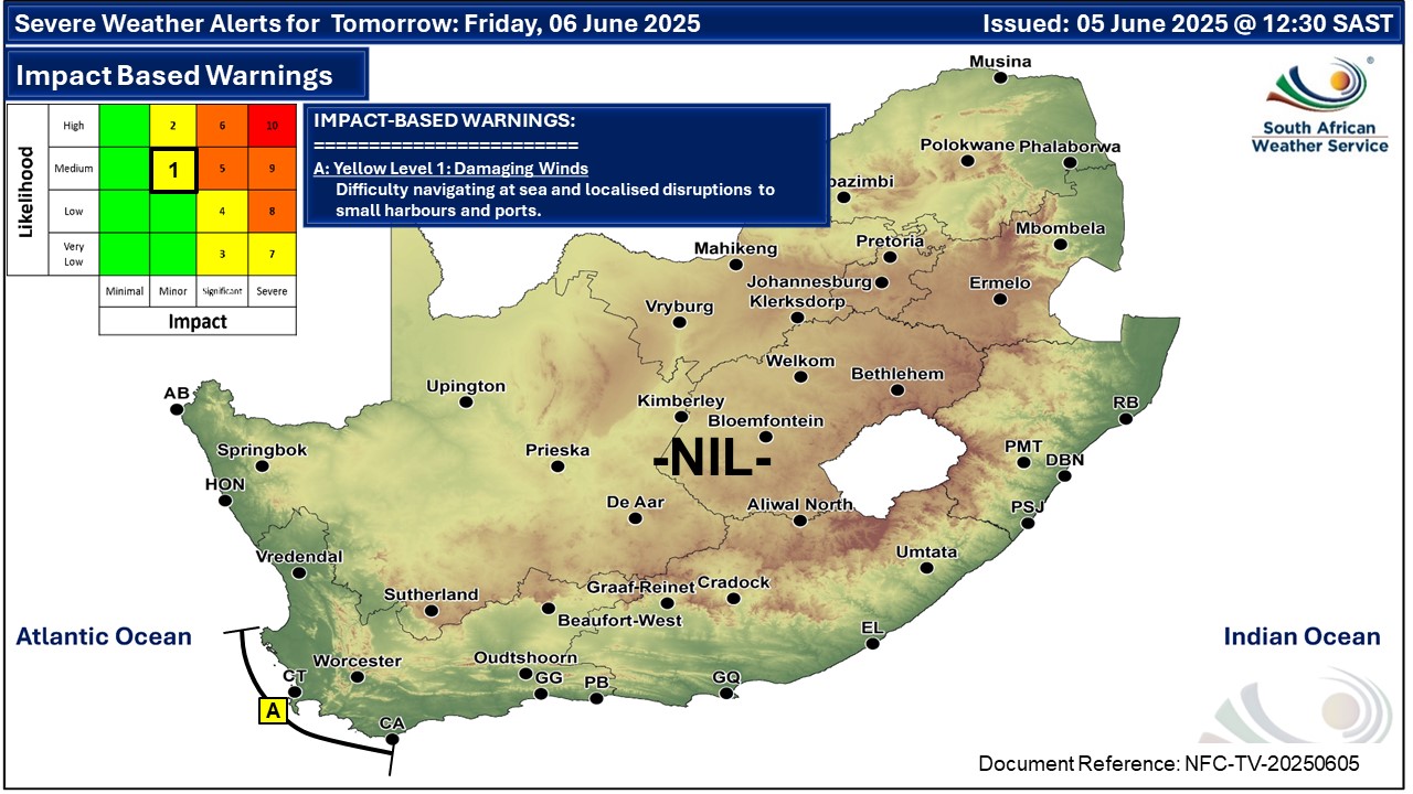
Impact-based warnings
A. Yellow level 1 warning for damaging winds leading to localised disruptions to small harbours and ports for short periods is expected between Saldanha Bay and Cape Agulhas from today evening into Saturday evening.
B. Yellow level 2 warning for damaging waves leading to difficulty in navigation at sea is expected between Saldanha Bay and Cape Agulhas on Saturday spreading to Plettenberg Bay from Sunday into Monday.
C. Yellow level 2 warning for disruptive rainfall leading to localised flooding and difficult driving conditions is expected over the City of Cape Town, Cape Winelands, western parts of Overberg and the southern parts of the West Coast District on Saturday into Sunday.
READ MORE: What is an impact-based weather warning?
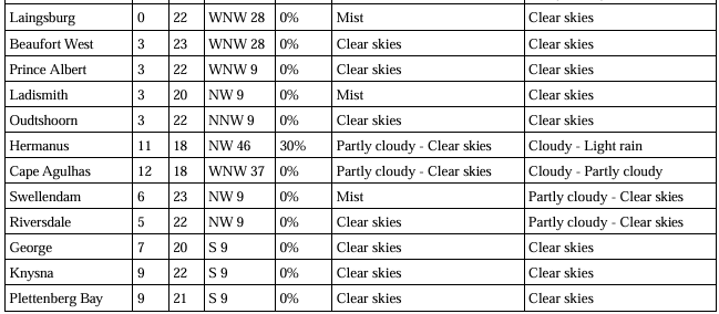
Weather forecast for Friday 6 June:
Western Cape
Fine and cool, but partly cloudy in the west. It will become cloudy in the south-west with light rain from the evening. The wind along the coast will be light to moderate westerly to north westerly, becoming fresh to strong along the south-west coast in the evening. The expected UVB sunburn index: Low
Western half of the Eastern Cape
Fog in places in the south, otherwise fine and cool. The wind along the coast will be light to moderate westerly, becoming north-easterly towards the evening.
Eastern half of the Eastern Cape
Fine and cool, becoming partly cloudy, with isolated showers and thundershowers in the north. It will be warm in places south of the escarpment. The wind along the coast will be moderate to fresh south-westerly.
Temperatures on Friday
‘We bring you the latest Garden Route, Hessequa, Karoo news’